Retreat Estate

Searching for the Retreat Estate Great House
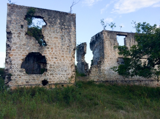
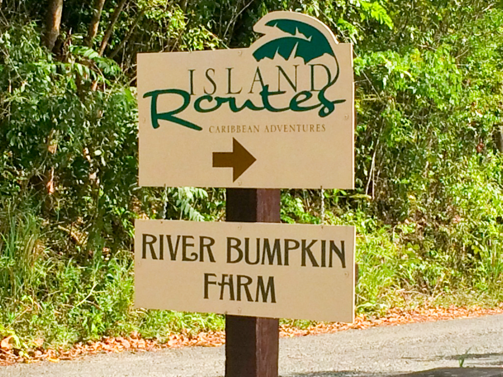
On Saturday, I turned off the hard road at the River Bumpkin Farm sign and made my way down the marl (weathered limestone) road to the office of the farm. There I met the good folks who worked at River Bumpkin Farm and they gave me a tour of the ruins of the Retreat Sugar Mill. The great house no longer exists.
Pirates of the Caribbean
Retreat was a property owned by Jane Stone who was a slave and became the wife of Jonathan Barnett who owned Barnett Estate. She also owned the nearby Hampstead Estate (covered in a previous blog). Retreat Estate had 180 slaves at the time of emancipation.
 Incidentally, I will charge off in a different direction here and discuss the capture of John Rackham by Jonathan Barnett, Jane Stone’s husband. John Rackham was better known as Calico Jack (he liked to wear calico), the pirate. Calico Jack is best remembered for two things: He designed and flew the famous pirate flag consisting of a skull and two crossed swords and also he had two female pirates in his crew…Mary Read and Anne Bonny. He cruised the Leeward Islands, the Jamaica Channel and the Windward Passage between 1718 and 1720.
 Governor Nicholas Lawes of Jamaica directed Captain Jonathan Barnett to take two privateer sloops on a mission to hunt down Calico Jack. The Tyger was heavily armed with several guns and twenty Royal Navy sailors and some British Army troops. At 10:00 PM on 20 October 1720, the Tyger discovered Calico Jack’s ship, the William at anchor in Dry Harbor Bay. The crew was drunk and sleeping as the Tyger silently approached the ship. Captain Barnet demanded that they surrender to which Calico Jack replied with a few shots from a swivel gun. The Tyger replied with a broadside and Barnett ordered his men to close and board the William. The pirates retreated to their cabins and the British sailors and troops quickly rounded up the pirates including a drunken Calico Jack.
Calico Jack and his pirates were taken to Port Royal tried on 16 November and hung on 19 November (speedy justice in those days). Mary Read and Anne Bonny pleaded pregnancy and avoided hanging at the time. Anne Bonny escaped but Mary Read was hung, but not before she issued the now famous saying, “If Calico Jack had fought like a man; he need not be hanged like a dog.”
The Sugar Mill
Kenroy Birch (also known as “Bug”) took me on a very informative tour of the ruins and surroundings. He pointed out the various plants. The farm also grows 27 varieties of bananas. The gentle trail wound along the river shaded by the verdant foliage.
The sugar mill was constructed adjacent to the Martha Brae River to harness the water to turn the rollers to crush the cane. The water was brought to the site via an aqueduct, which turned a water wheel, which via gears turned the rollers. The water mill was in operation until 1850 when it was shut down and the sugar mill operation was consolidated at the Hampstead mill using steam power.
Cane juice extracted from the rollers ran through gutters to the boiling house where it was stored in large cisterns call clarifiers and tempered with lime to remove the dirt. The juice was then heated and the scum was removed to be used in rum making. The purified liquid was boiled in a series of copper cauldrons of decreasing size, each getting smaller and hotter. The last copper was the smallest and hottest and the final product was a combination of sugar and molasses. The sugar was then taken to the curing house where in was put in wooden barrels (hogheads) with holes in the bottom to allow the molasses to drain out. After several weeks, the sugar, called muscovado, was ready to ship to Europe. For centuries, the skimmings were discarded until the enterprising sugar estate owners realized they could ferment it and produce rum. The crushed cane was stored in a trash house, allowed to dry and then used to fire the furnace in the boiling house. The products of both the curing house and the distillery were loaded on bamboo rafts and floated down the Martha Brae River to the coast to be loaded on ships.
River Bumpkin Farm
If you are looking for an educational adventure, I suggest the River Bumpkin Farm. You can go on the walking tour of the ruins and then having worked up a sweat, go tubing or kayaking in the Martha Brea River. They also have a beach and mountain bikes for a bit of additional exercise. When you get hungry, a canteen is available. The contact information is: Website: www.IslandRoutes.com; Telephone in North America: 1-877-768-8370; Telephone in The Caribbean: 1-800-744-1150; Telephone outside North America: 1-305-663-4364.
Retreat Estate Map | 1850

Retreat Estate Photo Gallery


Retreat Estate Location Map

Stewart Castle Estate

Getting to the Stewart Castle Estate
 For years, I have been driving by a sign that says, “Jamaica National Heritage Trust, STEWART CASTLE.” It was at the end of the day and I had just come through Duncans, saw the sign and said, “Stewart Castle…today is your day.” I turned off the north highway (A1) on to a dirt road and headed toward the ocean. I came to a “T” intersection that had a Stewart Castle sign but no arrow, until I looked closer and realized the black arrow was on top of the black portion of the sign. I turned right and followed the road up to the massive pile of rocks known as Stewart Castle. Fortunately, for me, there is a plethora of archeological and historical data available.
The History of the Stewart Castle Estate
First patented in 1754 by James Stewart I, Stewart Castle began as a small 167 acre landholding. By 1799, the sugar plantation had grown to well over 1200 acres and was supported by the labor of over 300 enslaved Africans. Despite the increase in size, James Stewart II needed to mortgage the property in 1797. At the time of its sale in 1830 by James Stewart II, Stewart Castle clearly was converted to cattle well before then, as it had an average of 282 cattle each year during the second decade of the 19th century.

James Stewart II led an active political and military life, serving as both the Custos of Trelawney Parish and as a Major General in the Militia. He served as a commissioner at the conference held with the Maroons at Trelawney Town prior to the beginning of the Maroon Wars in 1795. The almost obsessive focus on fortifications demonstrates a perceived and possibly very real threat to Stewart Castle from the Maroons and those he enslaved. If the Castle came under attack, Stewart had the ability to secure people and animals inside the courtyard, as well as ensure a large supply of safe drinking water as result of a large water cistern (3.1m x 5.5 meters by 2.5 meters deep) inside the main house.
Robert Sheldon purchased Stewart Castle shortly after Stewart II’s death in 1828 (An early 1830s lithograph by J.B. Kidd documents the overseer’s house and works, with the main house with its corner towers visible in the distance. Currently, the 1799 plat and the 1830 lithograph are the only surviving documents the directly address Stewart Castle.
A Description of the Stewart Castle Estate
The overzealous nature of the physical defenses around Stewart Castle, including a fortified privy, armored courtyard, and nearly 100 gun ports built into various parts of the compound, speaks to Stewart II’s concern for his personal security. The majority of the defenses face inland, toward the mountains and the Maroons, as well as toward the slave village. The lack of attention to defenses along the water suggest that Stewart’s main concern lay in the ability of the Maroons to attack and incite the enslaved population that substantially outnumbered white planters on the island throughout the eighteenth century.
The 1799 plat is the only map of the property and many of the represented structures remain visible today. The shell of a massive fortified masonry great house and privy and a well-defended courtyard remain standing near the center of the estate. Wharf piers and a few masonry walls of a storehouse from which hogsheads of sugar were shipped hug a stunning coastline. The remains of an overseer’s house overlook the ruins of the boiling house, cattle mill platform, and mill pond. Cobble piles representing remnants of Spanish-walled houses, a grave, and a cut limestone foundation mark the location of a large slave village that housed over 300 slaves in the early nineteenth century.
Today a path represented on a 1799 plat passes through the village and continues through a forest that was once the provision grounds for the estate’s enslaved laborers. Mango, guinep, ackee and coolie plum are still concentrated in this forest. The path continues over the crest of the ridge, and descends along a steep, rocky face before ending at the wharf. Fishermen still use a path who maintain a fishing camp in the eighteenth-century storehouse. One fisherman, who lives in the Refuge Community, a mid-nineteenth century free town near Stewart Castle, has been walking this path daily for over 60 years. His father walked the same path throughout the early twentieth century, likely traversing a route carved by his ancestors centuries earlier.
Research on the Stewart Castle Estate
The majority of research conducted at Stewart Castle has been archaeological and architectural in nature. Edward Chappell, Louis Nelson, and students from the University of Virginia have recorded the Stewart Castle Great house and Overseer’s House. Jillian Galle from Monticello and students from the University of the West Indies, Mona and the University of Virginia have conducted archaeological excavations within the fortified compound at the main house and at the slave village.
Architectural and archaeological evidence indicates that the Stewart constructed the Stewart Castle Great House in two phases. The first consisted of a cut limestone block house (approximately 28 feet x 24 feet) with a cellar and two detached towers. This phase likely occurred shortly after Stewart I patented the estate. The second phase of construction focused on greatly increasing the defensive capacity of the great house complex. Fortifications included a 16-inch thick, 8-foot tall masonry courtyard wall covered with broken late 18th century wine bottle glass, a large water cistern constructed on the interior of the great house for secure water storage, and a fortified privy complete with gun and cannon ports. The builders also constructed a wall with 36 gun ports constructed every ten feet around the edges. Archaeological research by the team of archaeologists from Monticello and the University of the West Indies confirm that the fortified courtyard was added during the second phase of construction at the main house, which likely dates to the early nineteenth century.
Acknowledgements
I would like to thank DAACS for their report on the Excavations at the Stewart Castle Main House and Slave Village as part of the DAACS Caribbean Initiative.
And the University of Virginia, Falmouth, Jamaica Field Guide.
Directions
The turn off to Stewart Castle is 6.4 kilometers east of Glistening Waters near Falmouth on the north highway or 2.5 kilometers west of the Duncan west exit off the north highway.
Join the Blog
If you are interested in additional great houses or the 1650-1850 colonial period of Jamaica, join my blog and you will receive additional email posts as they become available.

Stewart Castle Great House, Trelawny, Jamaica. This immense 18th Century fortified plantation house, complete with corner towers and loop-holed walls, was built in the 1770s by James Stewart of Appin, a wealthy Scottish Sugar Planter, and later owned by his son, the Hon. James Stewart (1762-1828), who was Custos of Trelawny from 1800 to 1821. From an Aerial Photograph by Jack Tyndale-Biscoe, c. 1970. Collection: Brett Ashmeade-Hawkins.
Stewart Castle Estate Photo Gallery


Stewart Castle Estate Location Map
Gales Valley Great House

The Challenge of Finding Gales Valley Great House
I had a bit of a struggle finding Gales Valley Great House. The trip to Hamden Great House was easy to find because a working sugar factory is there and they give tours (I will cover the Hamden Estate in a future post). The Hamden estate is adjacent to the Gales Valley Estate but at the time, I didn’t realize it. I headed west out of Wakefield, visited Hamden, backtracked into Wakefield, headed south and realized I must be past the estate according to the map. I then asked directions and a helpful man pointed back to the road to the Hamden sugar mill. I was told to follow the road that leads to the limestone quarry and sure enough, I found it near the top of a hill, surrounded by coconut trees, overlooking the large acreage of the previous estate. I found it abandoned. I was able to draw up a floor plan and it must have been a beautiful house at one time with a terrific view of the surrounding mountains and cane fields.
Description of the House
The split level wooden house is painted green and has a steep corrugated metal “M” type hip roof (two peaked roofs side by side). There is a large verandah facing north and the large slash and louvered windows allow the cool breezes to pass through the house. There are no ceilings, allowing the heat to rise and vents at the top of the interior walls allows great cross ventilation…a house built for the warm temperatures of Jamaica, rather than show. The floors are hardwood as well as the interior walls. As in most great houses of Jamaica, the living space is on the second floor. At some point, someone remodeled the house, adding an inside bathroom. A stairway in the living room leads to the ground floor. A separate kitchen out building is also built into the side of the hill.
History
William Gale originally owned Gales Valley Estate in Trelawny Parish and the York Estate in Saint James Parish both of which equaled 3,147 acres. He also owned Mount Hindmost Estate in Clarendon. The Gales also owned the pens and cattle ranches called St. Jago and Paisley. In 1820, there were 388 slaves at York, 262 at Gale’s Valley, 175 at Mount Hindmost and 40 at each of the two cattle pens. These numbers declined in later years. William was born on 7/15/1728 at Liguanea, St. Andrew’s Parish, to John Gale of Withywood and his wife Elizabeth Morant Gale. On 1/11/1753 at Vere, he married his first cousin, Elizabeth Morant. Elizabeth died on 6/14/1759 at age 31 and was buried at Vere Church. The couple had no children. William was a member of the Assembly for Hanover Parish in 1754-55 and for Saint John Parish in 1755-56.
The Gale and the Morant families came to Jamaica separately in the seventeenth century soon after the island was seized in 1655. Major John Gale (1637-1689) was buried there, as was John Morant who died in 1683. Various marriages linked their families, as they both acquired plantations, large estates, and great wealth. In 1754, John Morant owned 4,631 acres in Clarendon and 3,582 acres in Vere. Five members of the Gale family owned more than 6,000 acres of the island. In 1759, John Morant’s great-grandson Edward (d 1791) moved to England from Jamaica, where the family had built up extensive estates. He bought the Brockenhurst estate in Hampshire England in 1770, and his eldest son John Morant (d 1794) purchased the Manor of Ringwood from Henry 8th Lord Arundell in 1794. The Jamaican estates were handed down to subsequent generations of the family. Edward Gregory Morant (1772-1855) inherited his Uncle William Gale’s estates in Jamaica. Death duties on the death of a later Edward Morant in 1910 forced the family to sell the Ringwood properties in 1916. Many of the Brockenhurst estates were sold in 1951 and 1959.
The house is located west of Wakefield on the boundary of Trelawny and Saint James Parishes. Look for the quarry sign, turn left and it is on the top of the hill to the right of the road.
Gales Valley Great House Photo Gallery


Gales Valley Great House Location Map
Swanswick Great House

The good folks of Hampshire Great House directed me to Swanswick Great House, which was on a hill overlooking the Clarks Town. I turned left (south) off the paved road (B-1) and wound up the hill to the great house perched on top. Here another employee of Everglades Sugar Company met me and gave me a tour around the property. It is a two story house with living quarters on the second floor and an attached kitchen to the rear (unusual for colonial times). The kitchen was the same level as the house, built on pillars. The house is painted white and the roof has been replaced with corrugated metal. There is a large set of stairs in the front to the second story and a verandah across the entire back. One has to cross the covered verandah to access the kitchen. It is obvious, by a damaged wall that the builders constructed the house with timber supports, filled in with rock rubble and then they applied a coating of stucco.
Clark’s Town Township was a part of Swanswick Sugar Estate, owned by Mr. G. H. Clarke and from whom it derived its name. In fact, the Clarke family owned the whole of that area. Edward Clarke owned Swanswick; G. H. Clarke owned Long Pond, Hampshire and Mahogany hall and Sir S. H. Clarke owned Hyde. All these properties adjoin each other and my assumption is that the Clarkes were all related. These belonged to the Hyde-Clarke family of Hyde Hall in Cheshire, England, and Hyde Hall, Lake Otsego, New York. The Hyde-Clarke family continued to own Swanswick and Hyde plantations in Jamaica until as late as 1863. The plantations in Jamaica seem to have been originally owned by the Hon. George Clarke (1676-1760), who was Royal Lieutenant-Governor of New York from 1736 to 1743. He was the son of George Clarke, Esq. of Swanswick, near Bath, in Somerset, England and went out to New York in 1703, returning to England briefly in 1705 to marry Ann Hyde, the heiress of Hyde Hall in Cheshire, who was related to the Earls of Clarendon and to Ann Hyde, wife of King James II of England, the mother of Queen Mary and Queen Anne. Returning to New York, the Hon. George Clarke spent the next 40 years in America and established a vast estate of several hundred thousand acres in upstate New York, which he named Hyde Hall after his country estate in England. He eventually went home to England in 1745, with a fortune of 100,000 pounds sterling and, dying in 1760, was buried in Chester Cathedral. George Clarke’s elder son, George Hyde Clarke, inherited Hyde Hall in Cheshire, England, and his younger son, Major Edward Clarke (1716-1776), inherited Swanswick and Hyde plantations in Jamaica, and came out to Jamaica, where he married, about 1742, Elizabeth Guthrie Haughton, the daughter and heiress of James Guthrie of Auchindown Castle Estate, Westmoreland, Jamaica.
George M. Clarke gave the land for a mission near Swanswick and soon the congregation swelled so that in 1838 an Anglican stone church building was erected. This Church, built entirely of stone of the very best quality, has accommodation for 600 persons. The architecture is the old fashioned type, a miniature of the Falmouth Parish Church. The chancel, though small, is very artistic with stained glass depicting the saints. On entering this Church, one experiences an atmosphere charged with religious fervor for devotion. The church was originally named Swanswick Church but later the name was changed to Saint Michael’s which it is called to this day. On the walls of St. Michael’s will be found Tablets in memory of some of the illustrious departed. The first was George Marrett who died at Ashton Pen on 25th May, 1851. Aged 63. His sister, Sarah Marrett at Forrest Estate, October 1856, age 68. Charles Clarke at Falmouth in June, 1858, age 34; Paul King in 1859. Age 55. William Dalrymple, M.R.C.S., London, 1860, age 57; John Wilson, 1878, age 39, and the Hon. Leicester Colville Shirley of Hyde Hall and Etingdon, Custos, on the 21st October, 1914. Age 78.

Floor Plan of Swanswick Great House, Trelawny, Jamaica. From an Original Drawing by Kirsten Sparenborg Brinton, 2011.
Swanswick Great House Photo Gallery


Swanswick Great House Location Map
Hampstead Great House

Mike Schwartz told me that in order to get to the Potosi Estate I needed to turn on the marl (weathered limestone) road and follow it to the River Bumpkin Farm, an adventure concession owned by Sandals Resorts. I made my way down the five kilometers to the adventure company and was then told that they couldn’t give a tour of the Potosi Estate but if I could come back tomorrow, they would be glad to help me. I told the office girl about what I was doing and she suggested I go look at Hampstead Great House back on the same road. I back-tracked to the great house and there I met Paul Robinson who gave me a tour of the exterior of the great house and the sugar factory.
Hampstead was a property owned by Jane Stone who was a slave and became the wife of Jonathan Barnett who owned the Barnett Estate. She also owned the Retreat Estate nearby the great house. The Retreat sugar mill (I will cover it in another blog) ran using a water wheel on the Martha Brae River. The Hampstead sugar mill ran by cattle power. In 1850, the owner consolidated the two mills at Hampstead using steam power. At the time of emancipation, the estate had two hundred slaves.
The great house is remarkably nondescript. At the time, it was a really great house, but today, I’m afraid that it would be considered a middle class house. I drove to the top of the hill and as I started to take pictures, Paul Robinson, the caretaker, met me. He was unwilling to let me enter the house but gave me a first class tour of the property. We viewed the original kitchen outbuilding with a brick baking oven, as well as the barracks, where the house slaves lived. We then left the top of the hill and drove down to the ruins of the old sugar mill and rum distillery. I saw the furnace that both boiled the cane juice as well as made steam to run the steam powered mill. He also showed me the well, the water tank, the factory pond and the ruins of the building where the sugar was processed.
In order to get to this great house, take the Martha Brae exit from the north road, drive through Martha Brae on the way to Perth Town and follow the signs to the River Bumpkin Farm (to be described in a later post). Turn off the paved road, at the River Bumpkin Farm sign and about a mile up the road, you will see a coconut plantation on the left and a narrow track up the hill to the great house.
Hampstead Great House Photo Gallery


Hampstead Great House Location
Green Park Sugar Estate | The History

This is the first of two blog posts on the TheLastGreatGreatHouseBlog.wordpress.com. The first post will discuss the history of the estate and second post will discuss the great house itself. Much of the information is derived from the excellent research by Brett Ashmeade-Hawkins into the estate.
Green Park Estate was located approximately ten kilometers from Falmouth in Trelawny Parish. A portion of it was originally the Bradshaw Estate, named after James Bradshaw. Oliver Cromwell, Lord Protector of England granted to it to James Bradshaw in 1655 for the part his Father or Uncle (it is uncertain) John Bradshaw played in signing the death warrant of King Charles I. In 1660, King Charles II granted an adjacent estate to Richard Barrett and in 1706, Queen Anne granted 248 acres to Francis Egg who sold it to George Collier who renamed it Green Pond. George Sinclair bought the property from George Collier in 1740 and then built the first great house. In 1743, he sold it to William Clarke who built the second great house on the property, which was now 300 acres. He used is as a cattle operation. In 1759, Clarke sold the property to Edward Barrett who had inherited the Barnett Estate, increasing the property size to 742 acres. In 1759, Edward Barrett sold the property to James Peterkin who resold it to two Kingston merchants named John Kennion and Thomas Southworth in 1761. Thomas Southworth moved to the plantation, changed the name to Green Park and changed it from a cattle operation to sugar estate. Construction began on the present great house in 1764 by Thomas Southworth but he died before it was completed. William Atherton, Southworth’s heir, moved to the estate, took over the operation and completed the great house between 1768 and 1769.
During the 1770s, William Atherton expanded the estate by purchasing the adjoining Bradshaw Estate in 1771, which increased the size to 1,315 acres, and he added a second sugar mill in 1773 with an imposing stone windmill, which supplemented the mill powered by cattle. He imported hundreds of slaves from Africa to work in the cane fields and sugar factories of what was now the third largest estate of the eighty-eight estates in Trelawny Parish. William Atherton established himself, not only as one of the wealthiest sugar planters but also established himself as a merchant in the nearby towns of Martha Brae and Falmouth. Additionally he acted as the attorney for William Gale who owned the Gale Valley estate and Edward Hyde who owned the Swanswick Estate as well as several other planter families. (I will report on the existing Gales Valley and Swanswick great houses in a later blog. He also owned the Spring Valley Pen, which I will report on, in a later blog.) This made him an immense fortune and allowed him to purchase Prescott Hall, a country estate near Preston in Lancashire and retire to England in 1783. He died in 1803 and left the Green Park Estate to his nephew, John Atherton.
In 1810, the plantation records listed the estate having 550 slaves and 302 head of cattle. Green Park Estate stayed in the family until 1910, when the family decided to sell it to their Planting-Attorney, Walter Woolliscroft who had managed the estate for many years. In 1920, Mr. Woolliscroft made a fortune in the “Dance of the Millions.” In 1919, sugar sold for US$0.05 per pound:
1919 Average- US$0.05
January 1920- US$0.06 1/2
February 1920- US$0.095-the highest sugar had ever sold
March 2- US$0.10
March 18- US$0.11
March 27- US$0.12
April 8- US$0.15 1/2
April 18- US$0.18
May 19- US$0.22 1/2 this was the high when Mr. Woolliscroft sold his crop
By December the price was US$0.03 3/4
The price of sugar continued to fluctuate radically but usually higher that the average 1919 price which made Mr. Woolliscroft very wealthy but following the stock market crash of 1929, the price of sugar plummeted sending the Green Park Estate deeply into debt and forced Mr. Woolliscroft into bankruptcy. He sold the estate to Guy Milliner. Eventually the estate and sugar works were closed in 1957 and the last sugar cane crop harvested in 1963. Kaiser Bauxite Company bought the property to resettle farmers on five acre plots.
Green Park Sugar Estate Photo Gallery


Green Park Sugar Estate Location
Hampshire Great House

While I was in the hunt for Swanswick Great house, I noticed a great house out in the middle of a cane field so I cruised down the next available clay road through the field and pulled up to the great house. An extended family of an employee of Everglades Sugar Company presently lives in the house. The family sat around a large cast iron pot in which the mother washed her small daughter. I tried to communicate with the family about my desire to take pictures of the great house but I was unsuccessful because of my limited knowledge of Jamaica patois. Soon a man who came out of the adjacent kitchen building saved me. He was fluent in the King’s English and I explained my desire to photograph the house. He said, “Go ahead,” and allowed me to go about my business, all the while following me around.
The exterior appeared to be in good shape. The ground floor was constructed of cut, squared stone and the top was probably a timber and rubble type of construction that was covered with stucco. The hip roof is presently corrugated galvanized metal but was probably originally cedar shingles since cedar is prevalent in the surrounding hills. Leading up to the second floor was a magnificent cut stone stairway built over a substantial arch. Three arched doors at the front of the building, on the ground floor, created a feel of opulence. There were many doors and no windows in the lower level, which probably were used for access to storage. By living on the second floor, the overseer could take advantage of any welcoming breezes.
Approximately one hundred feet from the house was the kitchen and storage building. It also was made of cut stone. As I walked up, a friendly goat and her kid ambled out of the kitchen to greet me. The family still uses the kitchen; in fact, dinner was cooking over a charcoal fire. I’m not sure if the family invites the goats for meals. In colonial times, the kitchen was always separate from the house because of the risk of fire and to keep the heat out of the house.
Richard Brissett who originally owned Hampshire Estate also owned the Berkshire Estate. These estates are adjacent and Hampshire is about halfway down the main road (still known as Hampshire Lane) from the Clarks Town to Jackson Town. In 1840, the Jamaica Almanac reported that it consisted of 1560 acres and belonged to the Sir Simon H. Clarke, who also owned Mahogany Hall Estate and Long Pond Estate. The adjacent Clark Town is named after him because he donated the land to ex-slaves following emancipation in 1832.
Hampshire Great House Photo Gallery


Hampshire Great House Location Map


To Receive Future Posts

Recent Comments